Monday, 29 October 2018

Pauri Garhwal: Amazing Beauty

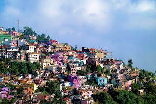
   Pauri Garhwal's Beauty does not add anything. Yes, every aspect of mountain beauty in the Pauri Garhwal is formulated.

   Perhaps this is why the country's tourists Pauri are attracted to the attractions of Garhwal. Located at an altitude of 1814 meters above sea level, Pauri Garhwal is a prosperous city situated in the lap of the Himalayas.
   Here is a different cultural, religious and spiritual tradition of its own. All-round beautiful plains - the valleys put Pauri in the beautiful beauty of Garhwal. It appears that there is a migration in nature's lap. 

   Pauri throws the flow of rivers somewhere in Garhwal, then somewhere snow summers give a sense of beauty. The forest series is also very visible. Like the lungs in the Pauri Garhwal, the lungs have oxygen feathers. The calm mind of the calm and cool air throws the mind. 
   The snow peak of Pauri Garhwal, covered with ice sheet, makes a dreamy world feel. This beautiful city situated in the middle of the hills is a district of Uttarakhand. Indeed, Pauri Garhwal is situated on Kandolia hill in the Himalayas. 

   Pauri Garhwal keeps the picturesque beauty of hill station along with antiquity. Due to its elevation, Pauri Garhwal's climate remains very pleasant for the year. So tourists can visit this oldest city and hill station anytime. 
   Especially, Pauri is a series of glorious rivers in Garhwal. There are Alaknanda, Hainval and Nair in the non-navigable rivers. Pauri's main language is Garhwali. 

   However here Hindi and English are also spoken. Garhwal's folk songs - music, dance and culture have a different tradition and charm. If you look at the geographical condition of Pauri Garhwal, this mountainous city is circular. 
   There are Chamoli, Rudraprayag and Tehri Garhwal in the north. Udham Singh Nagar in the south, Almora, Nainital in the east, Dehradun and Haridwar cities in the west. It is a special attraction of Uttarakhand, a beautiful city situated in a radius of 5440 square kilometers.

   The summit of the all-round mountain range creates a wonderful adventure, while the green plains - the valleys feel the velvety touch. Dense forest areas provide cool coolness. Tourists can take a lot of snowfall in Pauri Garhwal. 
   Tourists can feel the touch of clouds in the midst of this coolness. Due to high altitude, the blooming of the clouds continues steadily. Pauri is a long series of attractive and beautiful places around Garhwal and its surroundings. 

   Among them, there is a lot of things like Kandolia Shiva Temple, Binsar Mahadev, Tarakunda, Kanvashram, Dudhotoli, Jwalpa Devi Temple etc.   Kondolia: Condoleya is considered to be the place of God Deity. Kandolia is about two kilometers away from Pauri Garhwal. This temple dedicated to the goddess Kandolia is actually the Shiva Temple. Here the worship of the main deity is mainly. 

  The beautiful gardens and giant grounds are the main attractions of Condoleya. Close to this, Asia's largest stadium is considered as a lance. If you call Candolia an ideal picnic spot then there will probably be no exaggeration. There is also the Gangwaryan valley nearby.   Binar Mahadev: Binar Mahadev is situated at an altitude of about 2480 meters above sea level. Binar Mahadev is actually situated on Mount Peak, 115 kilometers away from Pauri Garhwal. 
    Binars are known to be specially known for natural beauty. The statue of Lord Shiva-Hargauri, Ganesh ji and Mahishasurmardini is installed in Binder Mahadev Temple. It is believed that Binder Mahadev was established by Maharaja Prithvi Singh in remembrance of father's point. This divine-magnificent temple is also called Bindeshwar temple.

   Tarakund: Tarakund is a beautiful place situated at an altitude of about 2200 meters above sea level. Tarakund's natural beauty attracts tourists exclusively. The view from here is enchanted. It appears that as lost in nature.  

   The beautiful lake and ancient temples make the beauty of the temple here. It is said that Pandavas came here during the ascension. Pandava had built the temple only. This place is also dedicated to the land god.   Kanvashram: Kannavashram is situated on the banks of the Malini river. Kanvashram is located about 14 kilometers from Kotdwar. This ashram is of sage Kanva. The ashram has mythological and historical significance.  

   It is believed that Maharshi Vishv Mitra had done penance here. Maneka had dissolved the reluctance of Vishwamitra here. After this Maneka was born in a virgin form and Paradise was returned.
   Later this girl was known as Shakuntala. Shakuntala was married to the Maharaja of Hastinapur. Shakuntala's son was named Bharat After becoming the king of India, the country was named India. From this point of view, this place is considered as special significance.
   Doodhtoli: Doodhtoli is considered to be the hottest area. The height of Doodhtoli from the sea level is 3100 meters. This area covered by forest area is a magnificent dimension of natural beauty. Particularly that the Doodhtoli is surrounded by the Himalayas. The surrounding bird's view shows here.   Jwalpa Devi Temple: Jwalpa Devi Temple is dedicated to Mother Durga ji. The recognition of this place is of Shaktipeeth. This temple is situated about 33 kilometers away on Pauri Garhwal-Kotdwar road.

   All necessary resources are available for Pauri Garhwal tour. The nearest airport is Jolly Grant Dehradun. Jolly Grant Airport Distance from Dehradun to Pauri Garhwal is about 155 Kms.  
   The Nearest railway station is Kotdwar. Distance from Kotdwar to Pauri Garhwal is about 108 kilometers. Tourists can also travel to the city of Pauri Garhwal by road.
30.148500,78.774500

Friday, 26 October 2018

Narendra Nagar: Every Color of Beauty

   Call Narendra Nagar a unique city, perhaps there will be no big deal. Every color of nature here makes Narendra Nagar a rainbow. 

  This city of Uttarakhand also has a specialty of tourism with mythology. Even if Narendra Nagar is a small town of Uttarakhand, its history is very rich. Located around 15 kilometers from Rishikesh, this mountain city became special in 1903. Because at that time, 

   King Narendra Shah of Tehri states decided to take the state capital from Pratap Nagar and make the city of Narender. A long series of beautiful buildings were developed specifically for the Tehri Principals. Surrounded by beautiful trees of alpine, Narendra Nagar is located at an altitude of about 1322 meters above sea level. As the legendary city, 

   The magnificent form of Narendra Nagar is seen as a tourist destination. Beautiful and spectacular appearance of the Himalaya from Narender Nagar, the beautiful and spectacular landscape is thrilled by the tourists. In fact, Narendra Nagar has a distinct and distinct place in the tourism sector. Narendra Nagar is literally the peak point of Rishikesh.  

   There is the grand-divine view of the river Dawon, Yamunotri and Gangotri from Narender Nagar. The Royal Palace is well-known for its special beauty and architecture. Particularly that the climate and natural surroundings of Narendra Nagar shines the mind and brain with a thrill. 

  The mountain peaks covered with ice sheet speak beautifully to the beauty. Yoga-meditation on the Ganges coast in Narender Nagar has its own unique joy and pleasantness.
  Apart from yoga, it is also the most suitable land for adventure sports. Ayurvedic treatment of Narendra Nagar is especially fame. Ayurvedic treatment here provides physical rejuvenation. 

   By which the tourists themselves feel very energetic. Near Aggarhal village is nearby. Tourists can also visit here to enjoy the folk culture. The peaceful surroundings provide a pleasant experience.

   The Terra Floors Temple of Narendra Nagar is famous in the whole of the country including Uttarakhand. Terra Manzil temple is dedicated to all the gods and goddesses of Hindus. Attractive and beautiful statues of gods and goddesses are established. 

   Due to its high altitude, the spectacular view of the sunrise and sunset is observed from here. From here you can see the surrounding bird's eye view.
   Kamakshi Devi Temple of Narendra Nagar is also known for its beautiful and elegant architecture. Visitors and tourists get a positive energy from the visit of Kamakshi Devi. 

   It is believed that seeing here brings strength, happiness and prosperity. After entering the city of Narendra, we realize that we are doing variance in nature's lap. 
  Due to the high altitude, the freezing of the snow and the clouds attracts the vibration. Narendra Nagar is a beautiful dimension of nature, architecture and beauty.

   All necessary resources are available for the visit of Narender Nagar. The nearest airport is Jolly Grant Dehradun. Distance from Dehradun to Narender Nagar is about 33 kms. 
  The nearest railway station is Rishikesh. The distance of Narendra Nagar from Rishikesh is about 15 kms. Tourists can also travel to the city of Narender by road.
30.121280,78.293940

Wednesday, 17 October 2018

Bekal Fort: Fantasticly Beautiful Structure

   If you call Bekal Fort a great dimension of architectural art and craftsmanship, then maybe something will not be wrong. 

  Located in Kasaragod of Kerala, this divine-gorgeous fort is very visible. Perhaps this is why it has been declared a tourist destination. Particularly that Bekal Fort is one of the main tourist destinations of Kerala. See, Bekal Fort comes under the category of coastal fort.

   This beautiful fort is located on the Arabian Sea coast of Pallikkare village, about 15 km south-east of Kasaragod. Experts believe that the Bekal Fort was organized and constructed by Shivappa Nayak. Due to its proximity to Karnataka, the strategic importance of Bekal Fort remained special from Vijaynagar.  

   It is also recognized that Bekal Fort was present during the reign of Kolathiri kings. Bekal Fort's divinity-grandeur is very birding. The beautiful structure of the Bekal Fort spread over 40 acres of area captivates tourists. The walls of the fort structured with Latterite stones are 12 meters high.  

   The fort is also connected to the sea. Selection of the site for the fort was very intuitive. Due to the fort, the whole scenario of the area is visible. There are ramparts and sides in the direction of the sea.
  A turret is built for guns in between. The full fort with the main door is protected from turret. The important thing is that there is a terraced tank in the fort.  

    The tunnel explains the secrecy of the fort and there is also a barroom to keep the ball rolling. There is a wide way to go to the surveillance platform. Experts believe that secular and religious rituals are also found in excavation. Mint could also be discovered in excavation. This includes the medieval castle complex. 

   This fort, built at a height of 130 feet above sea level, is a panoramic dimension of beautiful structure. The elegant look of Sunrise and Sunset from Bekal Fort seems to be very tempting. Bekal Fort is also a beautiful heritage along with natural Sushma. The Beckel Fort, filled with natural beauty, has a distinct place in the world due to its specialties. 

  This place also displays communal harmony. Hanuman ji's muktapanaana temple and the ancient mosque are the splendor here. In fact, the Bekal Fort is the confluence of land and sea. Experts believe that Bekal Fort is the largest and most beautiful fort in Kerala. 

  Although it has a long history of its own. Yet the fort is about 500 years old. The Indian Archaeological Department has declared it a special tourist area. The specialties here attract tourists, historians and nature lovers.  

   Not only are the lush green grasslands of tourists appealing to the tourists, but also the mind of blooming. The waves of the sea are thrilled. It can also call an ideal picnic spot. Tourists can roam around in Bekal Fort or roam in the morning from sunrise to sunset.


   All the necessary resources are available for the journey of Bekal Fort. The nearest airport is Mangalore. The nearest international airport is located in Calicut.  
  The distance of Bekal Fort from Calicut Airport is about 200 kilometers. The nearest railway station is Kasargod junction. The distance of the Bekal fort is about 12 kilometers. Tourists can also visit Bekal Fort by road.
12.394680,75.034410

Tuesday, 16 October 2018

Katarmal Sun Temple: Special Architecture

    The architectural and artistic art of the Katarmal Sun Temple attracts tourists especially from the rest of the world. 

    The Katarmal Sun Temple is located in Alocha, situated in Agash, Uttarakhand. Located at a height of 2116 meters above sea level, this Sun Temple is the center of attraction of the world. The architectural art of Katarmal Sun Temple situated in the Aphedli village is unique. In its structure, there are various aspects of artistry that are directed.

    Experts believe that the structure of the Katarmal Sun Temple was done during the reign of the Katyari dynasty. In the highlands of Kumaon, the Katarmal Sun Temple has its own distinct dimension of mythology and historicality. Experts believe that this Sun Temple of Almora is one of the oldest sun temples in the country.

   Experts believe that the construction of the Katarmal Sun Temple was made between the 6th and 9th centuries. This structure series of beautiful stones is very visible. 
   Explains that the structure of Katarmal Sun Temple was done during the reign of the ruler Katarmal of the Katyuri dynasty. The peak of Katarmal Sun Temple dedicated to Sun God may have been broken, but the greatness, divinity, grandeur and splendor still thrive.

   The main Katarmal Sun Temple is a spectacular series of more than 45 small temples. The structure of the main temple is Triatha. The square is built with a crevice crematorium with a sanctuary. The gateway of the sanctum has an insignificant engraved of wood art. Although some of its remains are displayed in the National Museum located in New Delhi.  

   The mythological significance of Katarmal Sun Temple is not even less. Experts believe that in the penance of the sages of Uttarakhand, the troubled people in the penance of Rishis Muni were disturbed.  
  The atrocities have been tortured. The troubled Sages of the Tribes have praised and worshiped Sun God on the Kanger Mount. Sun God was pleased and established his divine fast in Vatsala.  

   On this same Vatashila, the ruler of Katari Dynasty, Katarmal built Surya Mandir in the form of a holy shrine known as 'Bigditya'. Later this sun temple became known as the Katarmal Sun Temple.   
  Now this place is known to be known as Katarmal. If the experts believe that the Sun Temple is considered as the tallest, vast and unique temple in Kumaon Circle.

   After the Konark Sun Temple of Orissa, the Katarmal Sun Temple is considered as the oldest sun temple. Seeing its grandeur and divinity, the Archaeological Survey of India has declared it as a protected monument.  

  Sun God belongs to the main deities. Sun God is considered as the basis of all creation. In India, worship of Sun God is performed with reverence and dedication. If the experts believe that the Katarmal Sun Temple is restored from time to time.

  It is also called Big Aditya Surya Temple. Particularly in this temple of Lord Deity, the statue of Lord Aditya is not of any metal or stone but of wood. This temple, which is facing the eastern direction, is considered as unique. The structure of the temple is based on civil style.

   All necessary resources are available for the visit of Katarmal Sun Temple. The nearest airport is Pantnagar. The distance of the Katarmal Sun Temple from Pantnagar Airport is about 135 kilometers. The nearest railway station is Kathgodam. The Katarmal Sun Temple from Kathgodam railway station is about 130 kilometers away. Tourists can also visit Katarmal Sun Temple by road.
29.843050,79.337480

Monday, 15 October 2018

Dwarahat: Ancient Beauty of Temples

   Anyone can be enchanted by seeing the beauty craft of Dwarahat. If you call it a mythological and historical small town, there will probably be no obscurity. 

  Uttarakhand's Jihad is actually a beautiful populated area of ​​the mountainous region. Dwarahat of Almora district has a special place in the world due to its specialty. Located about 21 kilometers from Ranikhet, it is particularly famous for the Jatahat temples.  
   It is very special that many temples are without statue but the beauty of the temples is seen only after the craft. This beautiful area of ​​the mountainous region has a specialty of temples in its lagoon.

   According to experts, there are 3 categories of temples in Dwarahat. These are called kachari, maniya and rathnadev. Dwarahat's temples show the mythology and historicality on their own. Historically, Dwarahat has special significance.  
  Here the temple of Gujde devas is considered as the most important. Its craft beauty and its antiquity are distinctive. From the point of view of artistry, this temple can be called excellent. 

  The temple has been embellished with a series of murals and art pieces all around. The temple of Mata Sheetala Devi of Dwarahat is also divine-grand. Dwarahat is also known by many other names, including Vairatapattan and Lakhanpur. In the popular folklore of Kumaon, Dwarahat is also called the Capital of the Gods. A big reason behind this is that Dwarahat is situated in the middle of the geographical area of ​​Uttarakhand.  

   The saying is that the gods had chosen Dwarahat as the capital. Its beauty and grandeur is parallel to the Dwarka of Krishna in south India. It is believed that the plan of this city started, then it was decided that the confluence of Ramganga and Kosi rivers should be made here. 

   The Gods urged to inform Ramganga and Kosi immediately from the river Gangas. The situation remained that due to obstacles, Dahahat could not become the capital of capital. Yet Dwarahat's mythology, historical and beauty craft is incomparable. In this region of Uttarakhand, the rule of the Chiefs and the Chands rulers in particular.  

   The Katyuri rulers had set up Kartikeyapur town under the name of Shiva son Swami Kartikeya, near Garhwal Joshimath near Baijnath village along the Gomti river. They come under the hats by all terrain. Experts believe that from 12th century to 14th century the branches of Katari dynasty were spread from Hat to surrounding areas. 
   Located at a height of 1510 meters above sea level, Dwarahat maintains a special identity for coolness and beauty. Well known for the beauty and temples, the Dwarahat is also known as the village of temples. Dunagiri and Nayana Devi Temple are recognized as power stations. It is believed that rare herbs are grown in the inner area of ​​Sanjivani Shakti temple. 

   Due to the long series of temples in Dwarahat, it is also called Khajuraho of Kumaon. Dwarahat makes tourists realize the journey of the golden and god folk. The Mahamrityunjaya temple of Dwarahat is very special. This temple is dedicated to Lord Shiva-Ditunjaya, or those who have triumphed over death. This temple is built in the Nagar Peak style. 

   There are many things in the sanctuary, the interval and the Mandap etc. The craft of the temples of Dwarahat is distinctive. If goddesses have been carved by carving the stones, then the beautiful dimensions have been fabricated. 

    Due to the mythology, historicity and beauty of Dwarahat, tourism has wings of development. Therefore, this attraction attracts tourists from India and abroad towards this mythological city. Due to being situated at a height of 1510 meters above sea level, 

   Dwarahat has also taken the form of hill station. Cool atmosphere and coolness make a pleasant feel. The ancient Mathadist Church is also a beautiful Nagina of the beauty of the city.
  All necessary resources are available for Dwarahat's journey. The nearest airport is Pantnagar. The distance of Dwarahat from Pantnagar airport is about 112 kilometers. The nearest railway station is Kathgodam Junction. The distance of Dwarahat from Kathgodam railway station is about 88 kilometers. Tourists can also visit Dwarahat by road.
29.774800,79.427300

Shanti Niketan: Cultural and Spiritual Heritage    Shanti Niketan should be called a spiritual heritage. Yes, Shanti Niketan is an in...